Denoyer-Geppert Polar Air Age World chart. Over the past decades I have collected maps and expanded my collection to a degree that it has literally ended up covering each wall of my home office, which I fondly call the map room (without any aspiration to Churchill’s war room!) Most maps in my collection feature cities that I have either lived in or visited and continue to admire as part of my autobiographical experience as an urban flâneur.

Metropolises such as New York City (Map of the Common Lands, 1861; Sanborn Maps 1916; Bollman map for the World’s Fair, 1964); Paris (Traité de Police plans by de la Mare, 1705; vintage metro maps,1950): London (Indicator Map, 1874); Rome (Letarouilly, 1841); Riga (view by Janssonius-Zeiller, 1653); San Francisco (Panama Pacific Exhibition, 1915); Switzerland (1714); Venice (1844), as well as many others that are part of my collection. For me, each map inspires metaphorical and poetic journeys as I continue to claim that I am a traveler and not a tourist (Many of the maps are featured in image 1).
Denoyer-Geppert Company
A welcome exception to any collection is always in order. Case in point, nearly a decade ago I purchased my first Denoyer-Geppert school map titled Polar Air Age World. I discovered it at an antique store located in Lexington, VA owned by a French woman. I immediately fell in love with the map that was prominently featured in the storefront window, but I had to return to acquire it after a desperate phone call to secure the map as the store was closed the day of my initial visit. It is one of two Denoyer-Geppert maps that I own. The other one features the city of Paris, France.
The Denoyer-Geppert Company was based in Chicago and was one of the premier educational map publishers in the US beginning in the early-mid 20th century (1910-1970). Its founder, Denoyer, prior to the founding of the company, was a professor of geography, and his future partner, Geppert, worked as a mapmaker. Thus, the perfect combination of talent, expertise, and vision for the company to focus on maps for educational purposes.
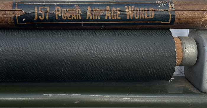
The maps were printed in color via offset lithography on high quality paper stock and typically mounted onto a linen canvas backing (Image 2). This was because the durability of the maps was needed as it had to resist daily rolling and unrolling, or touching by the small hands that aimed for the startling noise when the map flew up unhindered.
Today, the Denoyer-Geppert Science Company no longer produces maps and specializes in manufacturing anatomical models for educational intent.
Polar Air Age World chart

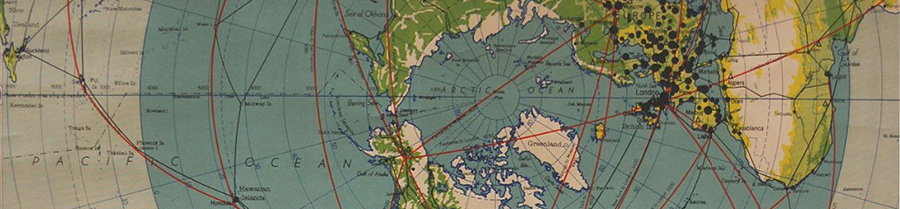
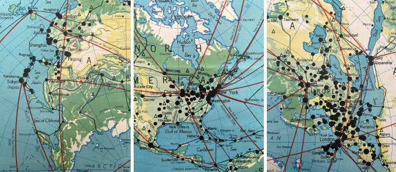
Printed in 1949, during the early Cold War, the title of this wall map reveals two important features that I wish to note: Polar Air Age World, and Polar Air Age World (bold emphasized by author). Three keys word—Polar and Air Age—that give us an opportunity to understand the importance of this map; and this, at the precise moment when it was published at the dawn of the Cold War. International travel surged after World War 2 due to military advancement in jet propulsion technology and the repurposing of airfields needed during the war. Perhaps the biggest advancement at that time, was that commercial flights started flying over the North Pole—the first verified flight was undertaken in 1954 by Scandinavian Airlines System (SAS) between Copenhagen and Los Angeles.
Polar Air Age World
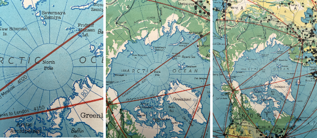
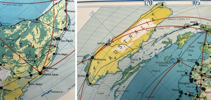
First a word on Polar. Most maps depicting the world use an imaginary griding of the earth through lines formed by longitude and latitude—which when they intersect, establish a precise location of any place on earth. Typically, in those maps, longitude is curved while latitude remain straight. While this map uses similar geographic coordinates, what is fundamentally different and key to the Polar system of projection, is that longitude is straight, while latitude lines are curved. This method of representation is called polar azimuthal equidistant projection.
While continental distortions remain true for all maps—including this one—the Polar map has the advantage that the closer you are to the north pole, the less distortion of the map’s representation. The further you move towards to equator (large blue circle) and the Southern hemisphere continents such as Australia, South America, and part of Africa, the more deformation will occur, thus producing an awkward representation of the continent below the equator compared to other map projections that we are accustomed to view (e.g. Mercator).
The main advantage of this method of mapping is that distances (azimuth) measured along any straight line radiating from a point are kept proportionally correct. In other words, the polar azimuthal equidistant projection of the world (also named Postal Projection in France and Russia) “is a cartographic map projection on a plane that accurately shows true distances and directions of terrestrial landmass areas from a central point.” In the case of our map, the North Pole is the central point from which both the northern and southern hemisphere landmasses are projected against the circumference of the earth at its largest longitude, which is the equator, shown by the edge of the dark blue circle.
An interesting note. Although already established as early at the 11th century, the polar azimuthal equidistant projection became more common during the 15th century to establish political boundaries between Spanish and Portuguese colonial rivals. Its use was to “…divide the non-European world into two spheres of influence along an imaginary [north-south] line.” This mutual agreement was called the Treaty of Tordesillas.
Polar Air Age World
Second, Polar Air Age World suggests the dawn of global aviation and intercontinental flight. Towards the end of WW2, Germany’s ability to perfect jet engines (e.g. Me262, V-1 and V-2 rocket engines technology) was capitalized on by the United States, which led leading rocket technology developer Werner von Braun to serve as a key US aerospace engineer after, ironically, being a member of the Nazi Party during the war. Many of these advancements set in motion a new age of aircraft propulsion.
These innovations, along with the establishment of international standards (e.g., International Air Transport Association (IATA) established in 1945) enabled commercial airlines to expand and merge among each other by offering a connectivity to the general public with faster travel time and longer transatlantic and transcontinental flights over the Pole, thus ushering the air industry into the Jet Age of travel.
Conclusion
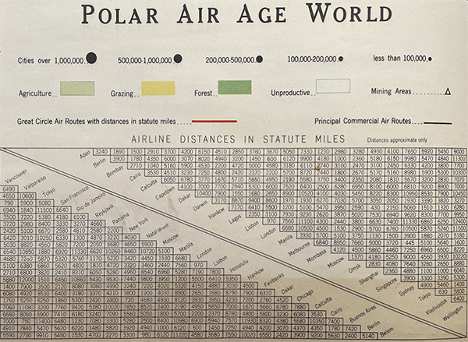
The Polar Air Age map’s purpose is to show air routes between major cities and continents, emphasizing how modern air travel shortened global distance, especially over the North Pole. Having such a map in a classroom—compared to later textbooks—became a visual aid for teaching geography, and historical and political boundaries, all the while giving students a sense of the incredible times they were witnessing. A new age that changed perceptions, distances, and geographic relationships.
Postscript 1
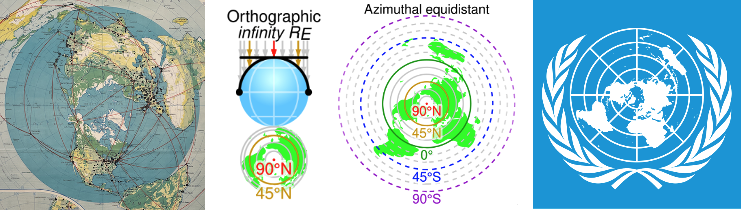
Interesting enough, this system of projection became emblematic for the UN flag, to the exception that Europe and not the United States are central on that flag.
Additional blogs on design issues
- Antique carpet stretchers
- About watches and their typefaces
- Swiss white wine glasses
- A compass set
- Harrods mid-century cocktail cabinet
- Lower deck lavatory: A340-600
- Mortician embalming cooling table
- Urban Posters in Paris, France
- Overnight sleeper train
- Post office Box Cabinet
- Secretaire a abattant
- Tri-fold mirror
- Vintage New York Postcards: Part 1
- Vintage New York Postcards: Part 2
- About miniature metal buildings
- New York vintage traffic signals